
Deep Content (1,500 to 5,000 characters (including spaces):
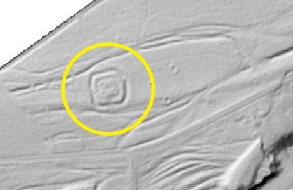
Within the framework of a historical-genetic reconstruction (HgR), it is common to research the building and use history of a property for a certain period of time. Not infrequently - for example, when assessing a suspected explosive ordnance - the period to be reconstructed extends to the time since the beginning of the Second World War. In addition to the actual focus on historical research and the evaluation of written sources and specialist literature, the supplementary evaluation of aerial photographs is of central importance for the preparation of a HgR, since historical aerial photographs often reveal important details, especially about war events that are hardly documented elsewhere, such as bombing raids, ground fighting or military operations. However, the informative value of aerial photographs reaches its limits where the view of the ground was blocked at the time the photographs were taken. Due to dense vegetation, forest and snow cover or cloud cover, the evaluation of historical aerial photographs is sometimes only of limited use. In these cases, a digital terrain model (DTM) created by laser scanning can be used as a supplement. In the DTM, the current terrain surface is visualised, but vegetation is not shown. This makes it possible to identify conspicuous features of the earth's surface, such as depressions (holes, trenches, etc.) caused by human intervention, which would otherwise remain hidden.
However, there are important points to consider when evaluating and interpreting a DTM. The state of preservation of historical soil structures depends essentially on later use. In forest areas, where there is usually hardly any ground movement, hollow forms, for example, are preserved over a very long period of time. In areas that have been exposed to construction, agricultural or military activities, on the other hand, the traces of historical use or influences are usually overprinted.
On the one hand, this means that where no traces of war events, for example, can be seen in the DTM, events may nevertheless have taken place which, however, can no longer be recognised in the meantime.
On the other hand, it also means that traces of past uses have been preserved over many centuries or even millennia until today and can lead to misinterpretations in the evaluation. It can happen, for example, that a DTM shows clear relics of an elaborate defence system, which, however, do not go back to combat operations of the Second World War, but under certain circumstances to medieval or even - especially in western or southern Germany - Roman castle and fortification systems.
In order to draw the right conclusions from the multitude of sources and circumstantial evidence when preparing a HgR and not to erroneously pronounce or deny a suspicion of explosive ordnance, it is therefore necessary to carefully reconstruct the history of a site and to work together in an interdisciplinary manner when evaluating all available information.
At M&P, this necessary expertise is bundled in a team of geographers, historians, archaeologists, geoinformaticians and geologists to draw the right conclusions from the available sources using state-of-the-art technology and precise, traditional scientific work. This is how we achieve the best possible results for our clients.
#mullandpartners #engineeringforabettertomorrow #HgR #Historical-genetic reconstruction #combatant pre-surveying #L aerial image analysis #DGM #Digital terrain model #Archaeology #history #combatant #mupgroup