
The evaluation of historical aerial photographs from the time of the Second World War is an indispensable aspect of the reconstruction of events that may have led to explosive ordnance contamination. The informative value of aerial photographs as "objective contemporary witnesses[1] However, this method reaches its limits where the view of the ground was obstructed at the time the images were taken. Vegetation cover, especially forest areas, can extend over large areas that cannot be analysed or can only be analysed to a very limited extent for traces of explosive ordnance. In these cases, a digital terrain model (DTM1) can be used to support the aerial photo analysis.
DTMs are usually based on data from airborne laser scans (LiDAR). The laser pulses are able to penetrate tree crowns. In this way, the current topography can also be measured under forest and visualised as a DTM. Since the terrain in forest areas usually remains unchanged over long periods of time, war impacts in the form of solid shapes (bunkers, positions) and hollow shapes (bomb craters, cover trenches and holes) can still be recognised in the DTM today.
The earth's surface in its present form is the result of complex processes during which structures from the most diverse times may have been preserved, passed away, overlaid and partly merged into one another. It is not only the war events of recent history that have left their traces. Often, solid or hollow forms are also relics of civilian use or military installations from earlier times far into prehistory. However, the danger of confusing traces of civilian use with the effects of war is particularly high in the case of medieval and early modern mining traces.
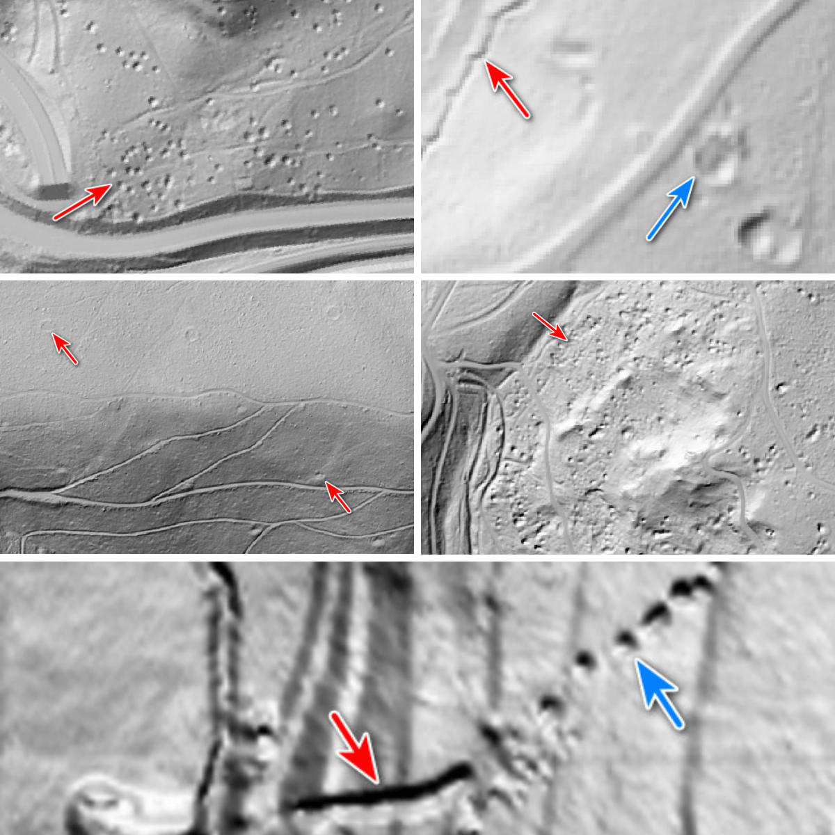
Near-surface mining of ores and other mineral resources can be achieved by sinking vertical shafts, so-called pits.[2], happened. These shafts are usually not secured and can therefore only be sunk to a depth of a few metres below the top of the ground. If further sinking is no longer possible or economical due to stability or water ingress, another shaft is sunk next to the first one. Over time, this creates a ping field or ping train. Over time, erosion fills the shafts until funnel-shaped pits with a diameter of a few metres remain in the relief of the terrain. These pits are usually surrounded by an earth wall consisting of the waste rock and the excavated material from the pits.
Adits and shafts from early historical and historic times were usually stabilised with simple wooden supports and often only backfilled to a small extent. If the wooden supports fail due to decay, the cap rock above the cavity can collapse. A round or elongated depression forms on the surface, a so-called daybreak.[3].
In order to keep the transport costs low, the processing of the mined ore usually took place in the immediate vicinity of the mining districts. Charcoal was used as an energy source. Since the transport of charcoal is far less costly than that of wood, the charring of the wood in the charcoal kiln usually took place directly in the forest. On slopes, round terraces, so-called charcoal plates, were used as sites for the charcoal kilns.[4]The area is characterised by a large number of rock formations with diameters of 20 m and more, some of which are still visible in the DTM today.
The described structures can easily be mistaken for war impacts. Charcoal slabs, pits and elongated cuttings can be misinterpreted as emplacements or cover trenches (cf. Figure 1&2 vs. Figure 3). Round open-cast fractures or pits with eroded earth walls resemble bomb craters (cf. Figures 4 and 5).
The most important clue for a correct classification when evaluating digital terrain models is the context in which the structures are located. If they are located in known mining regions (e.g. in the Harz Mountains or the Ore Mountains), this can already be a clue that they are mining traces. Neighbouring terrain formations can also provide information about what structures in the DTM are about. For example, charcoal burners are often located at regular intervals from each other at higher elevations near the mines. Therefore, if a large-scale DTM is available, in case of doubt, the wider surroundings of the features should also be considered with regard to further structures.
In order to reliably address the hollow and solid forms visible in the DTM and to make a reliable functional classification, experienced evaluators are ultimately required who are aware of the multitude of influences and the long periods of time that have created the present form of the earth's surface.
#mullandpartners #engineeringforabettertomorrow #DGM # Digital Terrain Model #Mining #Archaeology #History #Military resources #L Aerial Image Analysis #LiDAR #Vurveying #mupgroup